History
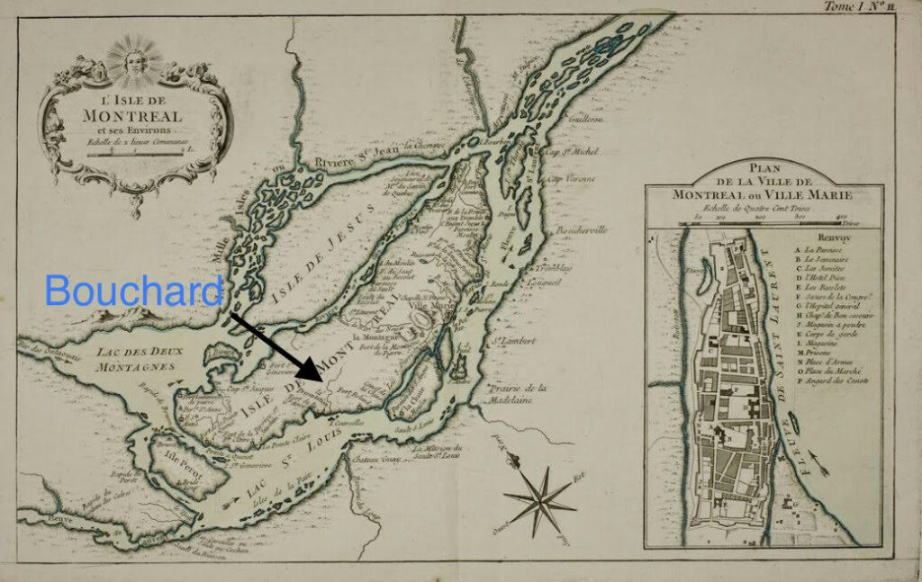
Bouchard creek is one of the oldest waterways on the island of Montreal, visibly described on maps from the 1600s and amongst the few that have survived to this day. It was once an important canoe route from Lac St. Louis to the centre of the island, and gave the city of Dorval its name.
Like most urban rivers Bouchard creek has struggled to survive as waterways are moved, blocked or deprived of fresh air and sunshine as they are forced underground by human development. The creek has survived the ravages from wilderness to fields to golf courses to airports to industries and residences – it needs our help to flourish going forward.
Evolution
The creek is named after Jean-Baptiste Bouchard d’Orval (circa 1658-1724), a fur trader and voyageur who bought land in what was then Fort Gentilly subsequently renamed Dorval. North America’s oldest golf club in continuous existence, the Royal Montreal Golf Club, built its main clubhouse for the period between 1896 and 1959 next to the creek. Dorval was a farming community and a resort area until the outset of the Second World War. In 1941 it became the home in Canada of the RAF Ferry Command and a military airport, today’s Montréal International Airport (aka ADM/YUL). After the war, this airport was an economic magnet. Two industrial parks, in the northern part of Dorval, have attracted aircraft, electronic, pharmaceutical and printing businesses. Dorval today is proud of its quality of life, its green spaces and its claim to be called “The City on the Lake ” referring to Lake St Louis which is a major widening of the St Lawrence river upstream of the City of Montreal which together with Dorval are both on the island of Montreal.
The creek is one of only a few bodies of water on the island almost entirely located within a single political and administrative unit of the many on the island. The creek’s watershed has been estimated to measure almost 9.1 km2 and to be impermeable over 55% of its surface. Dorval has the status of a municipality not a borough. Politically, the City of Dorval is divided into districts. Bouchard Creek in Dorval is entirely in electoral district 1 (2,400+ district 1 voters of a total 13,000+ Dorval municipal voters). The larger part of ADM/YUL is also only in District 1.
Bouchard creek’s sources are located under those paved sections of the ADM/YUL airport which may extend somewhat into the St Laurent borough. These flow hidden completely under the tarmac of ADM/YUL to emerge to daylight for the first time in Dorval just beyond the southern borders of the airport. The creek now flows south through and under a densely commercial, industrial section of Dorval, then alongside and under major highways and railroad tracks and finally through and under a mainly residential section of Dorval (including under the large Bell/Telebec parking lot at 200 Bouchard Boulevard) to empty into the St Lawrence river 1.2km upstream of the main water intake for the Lachine borough and several popular parks on the river.
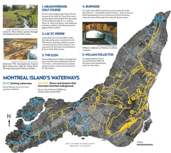
In the second half of the 20th century, much of the creek was straightened or covered to allow airport, highway, railroad, industrial, commercial and residential development. Several major and many smaller or chronic pollution incidents over the decades led to its being described in the late 20th and early 21st centuries as perhaps the most polluted body of water on the island. The creek was recently described as a biological desert by someone who, for many decades, had canoed up the creek from its mouth in the St Lawrence river and more recently taken water samples. In addition to both legacy and ongoing chemical pollution, urban litter of unimaginable variety accumulates relentlessly and is difficult to remove due to the preponderance of private property bordering the creek.
200 Bouchard
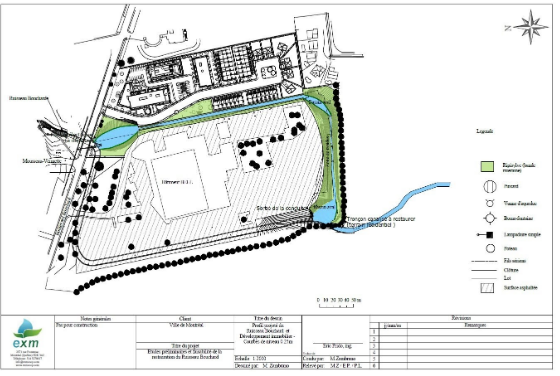
The large commercial property at 200 Bouchard is the longest underground segment of the Bouchard Creek with potential for daylighting. The main watercourse of Bouchard Creek flows for 500m across this property entirely through underground conduits, underneath grassy landscaping and paved parking. In 2014 the City of Montreal had the firm XMNaturae propose a concept for daylighting the Bell parking lot at 200 boulevard Bouchard. The proposed solution also impacted to a minor extent the neighbouring lot owned by the condo developer. At that time both Bell and the condo developer were in favour of the proposal despite the significant requirement to move several large Bell electric infrastructures. No request for direct financing by Bell and the condo developer was made. Today access to the creek by the general public is limited to perhaps 500m in the very narrow Mousseau-Vermette Park just upstream of the Bell parking lot. A plant restoration project was completed in a small section of this park by the City of Dorval in late 2019. The following image is the proposed design in 2014 for the Bell parking lot.
In February 2002 H&R Real Estate Investment Trust (H&R REIT) acquired 200 Bouchard. H&R has outlined plans to redevelop 200 Bouchard into a mixed-use development that aligns with H&R REIT’s broader strategy of focusing on residential and industrial growth while repurposing or divesting office and retail assets.
The proposed redevelopment envisions a mixed-use project that would include a combination of office space, retail components, and a significant residential element. Specifically, the plan includes the construction of approximately 800 residential units, alongside commercial spaces for offices and shops. Lobbying, planning and re-zoning began in 2021 leading to proposal plans in 2024 – this project is currently on hold.
Water Quality
A partial, sporadic sampling data on its quality of water started being collected and published by the City of Montreal only circa 2010. These suggest both specific chronic ongoing problems and important improvements most likely tied to ADM/YUL’s sustained efforts to reduce the impacts on the creek of its essential de-icing activities using glycol. Recurring periodic bad smells remain an undocumented problem for visitors to Mousseau-Vermette Park and any Dorval citizens with private property bordering the exposed parts of the creek. No data prior to 2011 on water quality or on toxins in the creek’s sediments have been located.
The Groupe de Recommandations et d’Actions pour un Meilleur Environnement (GRAME) worked hard in the 2010s to prevent the construction of new condos bordering the creek and to create a large green space centered on the creek. This effort failed. The final phase of this major condo development completed in late 2021. During that effort, approximately 2012-2014, basic data was obtained from the City of Dorval on the owners of municipal lots bordering the creek. Based on that data, at that time there were approximately 1300 owners (individuals and corporate) and 1800 cadastres most of which were owned by single different owners.
The most detailed and credible metrics found so far for the full length of the creek are to be found in a report in French only by the BPR firm commissioned by ADM/YUL and the City of Montreal entitled: <Etude hydraulique du ruisseau Bouchard> and dated June 23, 2010. No biological or ecosystem metrics for the creek appear in this report or anywhere else. Other significant documents about or at least mentioning Bouchard creek include the GRAME “Projet Revitalisation du Ruisseau Bouchard” October 24, 2012, the Daniel Arbour & Associates report of February 2005 and the ZIP Montreal reports of 1998 and 2011. All are available on our Resources page.
Thanks to the passion, hard work and generosity of the Bouchard creek community the Les Amis du ruisseau Bouchard project is underway from 2024-2029. For the first time in history a comprehensive characterization of the health of the Bouchard creek is underway – analyzing water quality, sediments, flora, fauna, macroinvvertebrates, plants, animals, birds and fish.